A new phase of the metaCCAZE project is under way in Kraków, Poland — using drones and artificial intelligence to capture how people, cyclists, and vehicles actually move through the city, rather than how traffic planners assume they do. The findings will inform the design of a future multimodal hub aimed at reducing car traffic, cutting emissions, and improving urban logistics and safety.
Kraków’s underutilise Grzegórzki district – situated between the UNESCO-listed Historic Centre and the River Vistula – is a living laboratory of urban mobility. Drivers, cyclists, and other road users move through the area not always where they should, and not always as the rules require. Drivers are violating entry bans, pedestrians and bikes share lanes designed for neither. Yet official traffic models rarely reflect this complex reality.
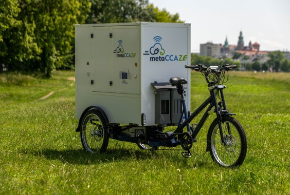
This is precisely the problem that Use Case KR-UC01-B sets out to address. Usage of drone-based mobility monitoring system with AI analytics will support the development of LajkHub as a multimodal node linking rail transport with lastmile solutions including cargo bikes. Delivered by the Municipal Public Transport Authority in Cracow (Zarząd Transportu Publicznego w Krakowie) in partnership with MobiLysis, under metaCCAZE will show how planned changes to key transport corridors affect traffic and cycling patterns and the use of shared mobility services such as LajkBike and Park‑e‑Bike. As Miłosz Kędracki, a member of the project team, puts it: ” The goal is to base transport decisions on real travel patterns rather than assumptions.” The drone system is fully mobile and modular, enabling distributed measurements across carefully selected urban research zones.
The aim is eminently practical. The data collected will serve as the evidence base for designing a multimodal hub that genuinely responds to real travel demand – prioritising cyclists, cargo bikes, and intermodal connections with regional rail – whilst measurably reducing car dependency. This directly supports Kraków’s commitments under the EU Climate Pact: less congestion, lower emissions, reduced noise, safer streets, and a more attractive neighbourhood – without compromising its critical logistical accessibility.
Progress to date
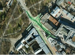
In September 2025, the first drone monitoring campaign was completed across seven carefully selected research zones within the study area. Each zone was chosen to represent a distinct type of everyday urban movement: junctions, delivery corridors, cycling routes, and mixed-use spaces where different user groups converge — and where breaches of traffic rules are, frankly, commonplace.
This first dataset establishes a baseline: a precise, evidence-based picture of how each location currently functions. It enables the team to pose — and begin answering — two key questions: how might each zone be reconfigured to improve mobility for all road users, and how could traffic patterns shift once heavy delivery vehicles are replaced by lighter, emission-free cargo bikes operating from the planned hub?
Next steps
A second drone monitoring campaign will repeat measurements across the same seven research zones. Conducting surveys at identical locations under comparable conditions is essential to producing reliable, comparable data and to identifying genuine shifts in mobility behaviour over time.
In the summer of this year, a sociological research phase will be launched using a dedicated mobile application available for download to Kraków residents and urban road users who want to shape their town and its future. Through in-depth surveys embedded within the app, the team will collect qualitative, “soft” data on how people experience and choose their mobility options – motivations, habits, barriers, and preferences that figures alone cannot capture.
Together, the drone data and the app-based sociological findings will form the analytical foundation for the future hub design.
More about our Follower City Kraków:
As part of metaCCAZE, an innovative transport hub will be created in the center of Kraków, including a new cargo bike station near the railway viaduct and Miodowa Street. This will enable the development of environmentally friendly, quiet, and zero-emission freight transport within the Second Ring Road. The cargo bikes will be managed using modern IT tools and supported by artificial intelligence, which will help organize an efficient delivery network – an attractive alternative to the current costly and burdensome solutions. Learn more here.